Your place to get your questions answered about this study.

Please see the posts below for helpful Q & A, and for your opportunity to contribute. Please remember to be respectful in your posts, and to visit our website www.vtwsr.org for up-to-date information!

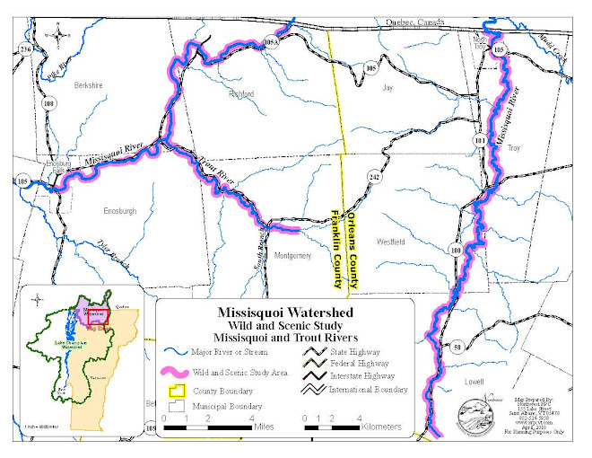
Study Area - Google Map

Saturday, June 16, 2012

Contact Us

More information is available on our website (http://www.vtwsr.org/), including the local Study Committee members from your town. 

Please contact us at:  info@vtwsr.org;
802-393-0076; or
2839 VT Route 105, East Berkshire, VT 05447

Our Next meeting is February 16, 2012 at the Enosburg Public Library.  Agenda will include the finalization of ORVs.

June is Vermont Wild & Scenic Rivers month!

We have many scheduled events and programs in June for you to enjoy and learn more about the Upper Missisquoi and Trout Rivers.  Click "read more" for a listing of events.

Sunday, April 8, 2012

Vermont Wild & Scenic Rivers Film Festival

Please join us for a Wild & Scenic Rivers Film Festival! We will be showing a collection of river-themed short and full-length films on two seperate nights:

Friday, April 20th
7:00-9:30pm
Montgomery Grange

and

Saturday, April 21st
2:00-4:30pm
Westfield Community Center

 Download the full schedule here.

T-Shirt Design Contest!

We are collecting submissions for our T-Shirt design contest.  The winner receives a dog sled ride from Montgomery Adventures! The second place artist receives two river innertubes.  
 
The Design Should Show:
  • What’s important about the Upper Missisquoi & Trout Rivers
  • How the rivers bring people together
  • What the rivers mean to you


The deadline to submit your artwork is May 4th, 2012.  All designs should be submitted to:
Shana Stewart Deeds
VT Wild and Scenic River Study
2839 VT Route 105
East Berkshire, VT 05447
info(at)vtwsr.org

Sunday, February 12, 2012

The Section 7 Process: Roles of The Wild & Scenic Study Committee and the National Park Service in VT Agency of Transportation Projects

Jamie Fosburgh, National Park Service (NPS), outlined the Section 7 process as it relates to a designated Wild and Scenic River.  He passed out a list of bridge projects the park service has dealt with on designated Wild and Scenic rivers.  Based on the input from the Study Committee, he anticipates that the covered bridges within the study area would be identified as an outstandingly remarkable value (ORV) and gave examples of the types of issues that have come up on other designated rivers.  He noted that the authority to review under Section 7 exists during the study period, not just once or if the river is designated. 

Focus on bridge projects – the range of Committee/NPS involvement and discussion bridge projects in designated rivers

Discussion of the Montgomery Covered Bridges as an example, with special guest Richard Tetreault from VTrans

Richard Tetreault is the Director of Program Development at VTrans.  He explained that when appropriate, VTrans aims to rehabilitate or restore covered bridges instead of replacing them with a metal structure.  He noted that there is a historic preservation officer at the agency and he pointed out examples of covered bridges that have been rehabilitated by VTrans.  Rich explained that there is a landscape architect on staff to deal with the issues of replanting trees/vegetation after a bridge or roadway project.  VTrans has also developed alternative state design standards so the state has more flexibility to design projects so you do not have to default to the federal standards that may not be appropriate for the rural context.  VTrans reached out to Oregon and New Hampshire DOTs to get their experience with Wild and Scenic process.  VTrans reviewed the regulations and did not see anything of concern.  He noted that there were “no show stoppers” for VTrans.  Rich suggested the committee contact John Narowski from the Environmental Section of VTrans. 

Monday, December 12, 2011

Upper Missisquoi and Trout Rivers Management plan to be completed in 2012

One of the study committee’s responsibilities in applying for federal Wild & Scenic designation is the creation of a management plan for the study rivers.  The management plan provides relevant background information on the designation process, describes the key features of the rivers (called Outstandingly Remarkable Values, or ORVs) that qualify them for Wild & Scenic designation, and outlines the priorities for management of the river and its ORVs if designation is achieved.  The basic structure of the management plan was discussed and agreed upon by the study committee at the November 17th, 2011 meeting in Richford, VT.  Please review the draft table of contents of the management plan; feel free to comment here or contact us about the plan structure or content.  You may view the draft plan outline here.

Wednesday, July 20, 2011

What is a Wild and Scenic River Study?

A congressionally authorized study to determine whether a particular river is eligible and suitable for designation as a National Wild and Scenic River under the Wild and Scenic Rivers Act which was enacted by Congress in 1968.  The process is entirely voluntary and in the hands of the local community members who are members of the Study Committee.  The National Park Service serves as a resource during the study.

Monday, July 18, 2011

What is a Wild and Scenic River Study Committee?

This Study Committee includes members from each of the ten towns and villages in the study area:  Berkshire, Town of Enosburgh, Village of Enosburg Falls, Jay, Lowell, Montgomery, Village of North Troy, Richford, Westfield, and the Town of Troy.  The official appointees were appointed by the town Selectboards.  There are also partner organizations on the Committee including:  the Vermont Agency of Agriculture, the National Park Service, and the Northwest Regional Planning Commission.  The mission of the committee is to gather information about resources along the rivers, protections which currently exist for these resources, and information about whether the local community understands and supports designation.

Is there a Committee established after designation?

If designation occurs a permanent committee will be established to manage the federal funds that typically result from designation.  I believe it will be formed similarly to the current committee where towns along the designated reach appoint members to the committee.  Either the National Park Service hires or designates a staff person to assist the committee and manage the river, or staff could also be hired through a partner organization such as the MRBA (as has occurred with staff for the Study – Shana). An example of how this occurred for the Lamprey River in New Hampshire can be found at: http://www.rivers.gov/publications/act/104-333.pdf (see Sec. 405).

What are the potential positive effects of designation?

  • If designated, Congress would appropriate funds for projects to preserve the recreational, scenic, historic, cultural, natural, and geologic resources in the upper Missisquoi and Trout Rivers.  These funds have been over $100,000 annually.
  • Landowners would still be the stewards of their lands.
  • If attracting tourists is a goal, designation could be a great marketing tool for local businesses and regions supporting ecotourism.  For example, there could be a check off list developed of New England’s Wild and Scenic Rivers, akin to those for the high peaks or birding destinations
  • Applications for grants may be more competitive in the areas designated Wild & Scenic.
  • A local Advisory Committee would be established to oversee the designation funds, and provide outreach for the recommendations in the Management Plan.
  • This Committee would have input during the review of projects (Section 7 Review) which are fully or partially federally funded, construction/development, and having a direct impact on the river.  These types of projects would be reviewed even without designation, but designation provides more local input into the permitting of these projects.
  • The Wild and Scenic Act was created at a time of large-scale dam building.  In an effort to balance dammed rivers with those which were free-flowing, there is a stipulation in the Act which prevents the establishment of new dams or hydro facilities on the designated portion of the river.  This does not affect pre-existing, permitted hydro facilities such as those in Troy and Lowell.  It also does not prevent existing dams from being retrofitted for purposes other than hydro.

Does Wild and Scenic Designation create a 1/4 mile protected corridor along the river?

It is probably more accurate to say that designation “establishes a flexible boundary on both sides of the river.” However, even this is subject to misinterpretation.

What the Wild and Scenic Rivers Act (WSRA) actually says in Section 3(b) is:
“The agency charged with the administration of each…wild and scenic river…shall…establish detailed boundaries…which…shall include an average of not more than 320 acres of land per mile measured from the ordinary high water mark on both sides of the river…”
(The complete act may be found at: http://www.rivers.gov/publications/act/current-act.pdf)

Important points to keep in mind:
  1. That works out to ¼ mile on each side of the river, but does not set ¼ mile as the boundary.
  2. The flexible nature of the boundary is intended to enable the Study Committee to capture most or all of the Outstandingly Remarkable Values (ORVs) within the boundary by varying its width as need be.  See our ORV blog http://vtorvs.blogspot.com/  or our website (http://www.vtwsr.org/) to find out more about ORVs.
  3. On rivers where there is existing federal ownership—i.e. a national forest—it clarifies which lands are subject to the WSRA and which are not.  For rivers where Congress has authorized federal land acquisition to implement the designation, the boundary established under Section 3(b) identifies which lands can be acquired, i.e. those within the boundary—see Section 6(a).  The upper Missisquoi and Trout Wild and Scenic rivers would be partnership rivers in private, not federal, ownership.
  4. For most—if not all—partnership rivers, Congress has expressly PROHIBITED the administering agency from acquiring federally owned land.
Even more importantly is how the boundary gets used once established in the management plan by the Study Committee—which is limited to Section 7 determinations and thus only applies to the construction of federally assisted water resources projects. Even then, the application of the boundary is simply to determine which standard the administering agency must use in evaluating the potential effect of the project on the rivers resources.

Jim McCartney - National Park Service

A member of a Westfield Selectboard asked if there was a specific buffer requirement in which there was Wild and Scenic protection.

If the Study Committee pursues designation, then they will establish boundaries for the designated area.  There is not a set rule for the size of the border along the designated river. The flexible nature of the boundary is intended to enable the Study Committee to capture most or all of the Outstandingly Remarkable Values (ORVs) within the boundary by varying its width as need be.  Having a boundary will not mean that the area is then controlled by the federal government.  Regulations which currently govern land use will still be in effect.  Please see the previous post entitled “Does Wild and Scenic Designation create a 1/4 mile protected corridor along the river?” for more information.

Ed states: There was talk of possibly including feeder streams in the designation. With this in mind, is there a "zone" or a specific distance from the center of the river the W&S designation would effect?

NPS Staff response: We are looking broadly right now at resources that are in some way related to the river. The time to narrow things down will be after we collect information about the rivers' resources at the end of the study - all tributaries to the Missisquoi and Trout Rivers are currently considered during the study. If our ORV work indicates that there are tributaries that have exceptional value and importance, the Study Committee could consider recommending that they be included in designation (subject to local support). In terms of deliniating a specific “zone” of influence along the river, we will have to wait and see what our management recommendations are, although we already know for sure that there is no “zone” of new federal land use restriction.

Ed goes on to ask whether there is a commitment of funds that the towns need to provide after designation.

NPS staff reply - Once designated, it would be the expectation that Congress would provide funds on an annual basis to hire the support staff and assist in Management Plan implementation through education and outreach. Just as any management recommendation that the Study Committee suggests are voluntary, any town/community support (financial or otherwise) would be voluntary both during the study and post-designation, should designation occur.

Saturday, July 16, 2011

Are all areas of the rivers classified the same way under designation?

There are three classifications under designation:
Wild river areas are those with the cleanest water, and the least amount of development around the shoreline.  These areas are typically only accessible by trail, and do not have impoundments.
Scenic river areas are those with clean water, and minimal development around the shoreline.  These areas may be accessible in areas by roads, and do not have impoundments.
Recreational river areas are those which may have some development along shorelines.  They are readily accessible by roads or railroads, and may have had historical impoundments or diversions.
Jeff asks -  
Can certain sections of the river, say an un-dammed tributary be designated "wild", while a different area that is dammed designated "scenic" or is it all of 1 designation or another?
Thanks for letting me know about your question.  The folks at the NPS confirmed my thought that different segments can be designated wild, scenic or recreational along the river, and that the whole area proposed for designation does not need to be just one of those categories.  So the answer to your questions is yes.
Thanks,
Shana

Friday, July 15, 2011

Ed asks: What are the guidelines, publication or regulations that the National Parks Service uses to oversee the W&S designation?

The National Park Service works with an interagency group known as the Interagency Wild & Scenic Rivers Council to ensure consistency in administering the Act. The Council has a number of publications on its website including a comprehensive list of Questions and Answers that can be found at:  http://www.rivers.gov/publications/q-a.pdf

Some additional resources may be found on our website: http://www.vtwsr.org/

You may access the whole W&S ACT legislation at http://www.rivers.gov/publications/act/current-act.pdf and the amendment that added our study to the act can be found at http://www.rivers.gov/publications.html#wsract scroll down to 2009 "Added Missisquoi and Trout for study"

Will Hunting and Fishing Be Affected?


No.  Hunting and fishing laws are unaffected by the designation.

Thursday, July 14, 2011

What deliverables come out of the study process?

Jamie Fosburgh's response: In the end, what Congress needs form "us" is a report that addresses: 1) do the rivers qualify for designation by having at least one ORV, etc. (or do different segments qualify); and 2) does designation make sense (this includes, do people want it, can the river be effectively managed to protect identified outstanding values, etc.)

I put the "us" in quotes above, because we will be reporting a wide range sentiment, including the NPS, the Study Committee, State agencies, the towns and their citizens, riverfront landowners, MRBA, and other partner organizations. All of the entities we have collected data from over the study process.

The Study Committee will produce two documents: the report to congress and a voluntary management plan. It is this second document that really expresses what the communities and river stakeholders want for the future of the river. It should have value to the communities and partners whether or not a Wild and Scenic designation is pursued. And, it is the key to answering the question of whether designation makes sense.

Tell me more about the voluntary Management Plan.

The Study Committee develops a Management Plan during their three year river study.  This plan is a compilation of the information collected during the study, and designed to help communities understand the resources and protections which exist for their river, and the recommendations gathered by the Study Committee.  This plan is non-regulatory, and the management strategies would be implemented through education and outreach.